A team led by glaciologists at UC Irvine used satellite radar data to reconstruct the impact of warm ocean water surging in a grounding zone extending several kilometers beneath Thwaites Glacier in West Antarctica. The research, the subject of a paper published in PNAS, will help climate modelers derive more precise projections of sea level rise resulting from the melting of ocean-terminating glaciers around the world. Credit: NASA/James Yungel
Satellite radar data shows substantial seawater intrusion beneath Antarctica’s Thwaites Glacier, causing ice to rise and fall.
Using high-resolution satellite radar data, a team of glaciologists led by researchers at the University of California, Irvine uncovered evidence of the intrusion of warm, high-pressure seawater many kilometers beneath the grounded ice of West Antarctica’s Thwaites Glacier. This glacier is often referred to as the “Doomsday Glacier” because of its critical role in potential global sea level rise and the catastrophic implications such a rise would have worldwide. This nickname reflects the glacier’s vast size and its significant melting rate, which scientists believe could substantially contribute to sea level rise if it were to collapse or melt entirely.
The UC Irvine-led team said that widespread contact between ocean water and the glacier – a process that is replicated throughout Antarctica and in Greenland – causes “vigorous melting” and may require a reassessment of global sea level rise projections. Their study was published on May 20 in Proceedings of the National Academy of Sciences,
Data and Observations
The glaciologists relied on data gathered from March to June of 2023 by Finland’s ICEYE commercial satellite mission. The ICEYE satellites form a “constellation” in polar orbit around the planet, using InSAR – interferometer synthetic aperture radar – to persistently monitor changes on the Earth’s surface. Many passes by a spacecraft over a small, defined area render smooth data results. In the case of this study, it showed the rise, fall, and bending of Thwaites Glacier.
“These ICEYE data provided a long-time series of daily observations closely conforming to tidal cycles,” said lead author Eric Rignot, UC Irvine professor of Earth system science. “In the past, we had some sporadically available data, and with just those few observations it was hard to figure out what was happening. When we have a continuous time series and compare that with the tidal cycle, we see the seawater coming in at high tide and receding and sometimes going farther up underneath the glacier and getting trapped. Thanks to ICEYE, we’re beginning to witness this tidal dynamic for the first time.”
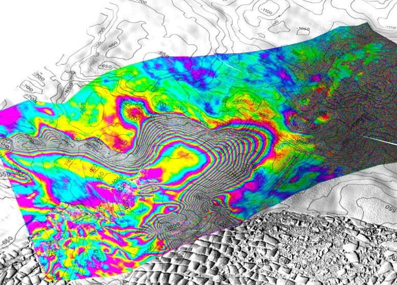
Screenshot of a 3D view of the tidal motion of Thwaites Glacier, West Antarctica recorded by the ICEYE Synthetic Aperture Radar (SAR) constellation based on images acquired on May 11, 12, and 13, 2023. Contour levels are bed topography contours at 50 m interval. Each interferometric fringe color cycle is a 360 degree change in phase, equivalent to a 1.65 cm displacement in line-of-sight distance of the ice surface. The interferogram is overlaid on a Landsat 9 image acquired in February 2023. In this study, we show that the limit of tidal flexing varies by kilometers over the tidal cycle, indicating that pressurized seawater is able to intrude beneath grounded ice over kilometers and set vigorous heat exchange with the glacier base. On the right side of the screen, a separate bull’s eye pattern indicates seawater intrusion propagating another 6 km beyond a protective ridge, indicating that the glacier retreat is still ongoing, at a kilometer per year in this critical sector of Antarctica. Credit: Eric Rignot / UC Irvine
Advanced Satellite Observations
ICEYE Director of Analytics Michael Wollersheim, co-author, said, “Until now, some of the most dynamic processes in nature have been impossible to observe with sufficient detail or frequency to allow us to understand and model them. Observing these processes from space and using radar satellite images, which provide centimeter-level precision InSAR measurements at daily frequency, marks a significant leap forward.”
Rignot said the project helped him and his colleagues develop a better understanding of the behavior of seawater on the undersides of Thwaites Glacier. He said that seawater coming in at the base of the ice sheet, combined with freshwater generated by geothermal flux and friction, builds up and “has to flow somewhere.” Water is distributed through natural conduits or collects in cavities, creating enough pressure to elevate the ice sheet.
“There are places where the water is almost at the pressure of the overlying ice, so just a little more pressure is needed to push up the ice,” Rignot said. “The water is then squeezed enough to jack up a column of more than half a mile of ice.”
And it’s not just any seawater. For decades, Rignot and his colleagues have been gathering evidence of the impact of climate change on ocean currents, which push warmer seawater to the shores of Antarctica and other polar ice regions. Circumpolar deep water is salty and has a lower freezing point. While freshwater freezes at zero degrees Celsius, saltwater freezes at minus two degrees, and that small difference is enough to contribute to the “vigorous melting” of basal ice as found in the study.
Impact on Sea Level Rise and Future Research
Co-author Christine Dow, professor in the Faculty of Environment at the University of Waterloo in Ontario, Canada, said, “Thwaites is the most unstable place in the Antarctic and contains the equivalent of 60 centimeters of sea level rise. The worry is that we are underestimating the speed that the glacier is changing, which would be devastating for coastal communities around the world.”
Rignot said that he hopes and expects the results of this project to spur further research on the conditions beneath Antarctic glaciers, exhibitions involving autonomous robots, and more satellite observations.
“There is a lot of enthusiasm from the scientific community to go to these remote, polar regions to gather data and build our understanding of what’s happening, but the funding is lagging,” he said. “We operate at the same budget in 2024 in real dollars that we were in the 1990s. We need to grow the community of glaciologists and physical oceanographers to address these observation issues sooner rather than later, but right now we’re still climbing Mount Everest in tennis shoes.”
Conclusion and Implications for Modeling
In the near term, Rignot, who is also a senior project scientist at NASA’s Jet Propulsion Laboratory (JPL), said this study will provide a lasting benefit to the ice sheet modeling community.
“If we put this type of ocean-ice interaction into ice sheet models, I expect we will be able to do a much better job of reproducing what has happened in the past quarter century, which will lead to a higher level of confidence in our projections,” he said. “If we could add this process we outlined in the paper, which is not included in most current models, the model reconstructions should match observations much better. It would be a big win if we could achieve that.”
Dow added, “At the moment we don’t have enough information to say one way or the other how much time there is before the oceanwater intrusion is irreversible. By improving the models and focusing our research on these critical glaciers, we will try to get these numbers at least pinned down for decades versus centuries. This work will help people adapt to changing ocean levels, along with focusing on reducing carbon emissions to prevent the worst-case scenario.”
Reference: “Widespread seawater intrusions beneath the grounded ice of Thwaites Glacier, West Antarctica” by Eric Rignot, Enrico Ciracì, Bernd Scheuchl, Valentyn Tolpekin, Michael Wollersheim and Christine Dow, 20 May 2024, Proceedings of the National Academy of Sciences.
DOI: 10.1073/pnas.2404766121
Rignot, Dow, and Wollershiem were joined in this project by Enrico Ciraci, UC Irvine assistant specialist in Earth system science and NASA postdoctoral fellow; Bernd Scheuchl, UC Irvine researcher in Earth system science; and ICEYE’s Valentyn Tolpekin. ICEYE is headquartered in Finland and operates from five international locations, including the United States. The research received financial support from NASA and the National Science Foundation.
Reference

Dr. Thomas Hughes is a UK-based scientist and science communicator who makes complex topics accessible to readers. His articles explore breakthroughs in various scientific disciplines, from space exploration to cutting-edge research.